Collaborative Georeferencing Project (2012-2015)
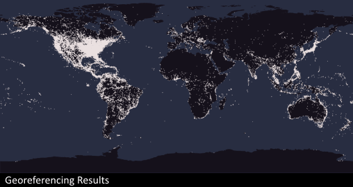
A collaborative georeferencing and data enhancement project titled "Georeferencing U.S. Fish Collections: a community-based model to georeference natural history collections" has been funded by the United States National Science Foundation. Twelve collaborating institutions are working to expand and improve data quality within the FishNet network with a primary focus on geospatial referencing records lacking geographic coordinates (approximately 45% of the network holdings at the time of funding).
Collaborators
- ANSP, Academy of Natural Sciences Philadelphia
PIs: John Lundberg & Mark Sabaj, Tech: Marianegeles Arce Hernandez - CAS, California Academy of Sciences
PIs: Luiz Rocha & Dave Catania, Tech: Lorenzo Benito - CUMV, Cornell University
PIs: Amy McCune & John Friel, Tech: Laura Porturas - FMNH, Field Museum
PIs: Mark Westneat & Leo Smith, Tech: Justin Grubich - LACM, Los Angeles County Museum
PIs: Chris Thacker & Rick Feeney, Tech: Paul DeSalles - TU, Tulane University
PIs: Hank Bart & Nelson Rios, Project Manager: Michael Doosey, Tech: Megan Roberson - FLMNH, University of Florida
PIs: Larry Page & Rob Robins, Tech: Michelle Vanderwell - INHS, University of Illinois at Urbana-Champaign
PIs: Chris Taylor, Tech: Rachel Vinsel - KU, University of Kansas
PIs: Ed Wiley & Andy Bentley, Tech: Katy Wichman - UMMZ, University of Michigan Ann Arbor
PIs: Bill Fink & Douglas Nelson, Tech: Diego Barroso - MSB, University of New Mexico
PIs: Tom Turner & Alexandra Snyder, Tech: Theresa Lorraine McInnes - UT, University of Texas at Austin
PIs: Dean Hendrickson, Tech: Melissa Casarez
Status
The georeferencing phase has been completed and we are now in the process of data repatriation.